Table of Contents
Main physical features of India:-
India is one of the most diversified countries in the World. It makes herself unique due to its political and physical features present in it. India has the main physical features of India which are based on natural vegetation, Climate, and Landforms.
India has its different ancient history and is the Land for 4 religions. They are Hinduism, Jainism, Buddhism, Sikhism. So physiography of India varies from state to language to religion.
According to the physical features of India, it can be divided into 5 Types:-
1) Northern Mountains
2) Northern Plains
3) Western Deserts
4) Southern Plateau
5) Coastal Plains and Islands
 |
| Types-Physical-Features-India |
1) Northern Mountains:-
- It is spread from Jammu & Kashmir to Arunachal Pradesh.
- The Total Length is 2500 Km and Width is 150 to 400 km.
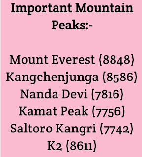
- It has the highest peak in World Mount Everest (8848 m), which is located in Nepal.
- There are many mountain ranges located in this part.
- The first human who climbed Mount Everest is Sir Edmund Hillary & Tenzing Norgay in 1953. Indian was Bachendri Pal in 1984.
- Animal found in Northern Mountains is Furry Yak.
- There are three types of Himalayas, Greater Himalayas, Middle Himalayas, and Outer Himalayas.
- Greater Himalayas includes Kanchenjunga (8598 m) and Nanda Devi (7817 m). It is less densely populated.
- Middle Himalayas include Pir Panjal and Dhauladhar (8172 m). Indus, Satluj, and Ganga are rivers that flow through here.
- Outer Himalayas include Karakoram Range and K2 Mountain (2nd Highest in World).
- Purvanchal Mountains have Garo, Khasi, Naga, and Mizo hills.
States:- Jammu & Kashmir, Himachal Pradesh, Uttarakhand, Arunachal Pradesh, West Bengal, and the other North Eastern States.
2) Northern Plains:-
- It spreads from Punjab to Assam.
- This is the most densely populated area in India.
- Rivers include here are Satluj, Ganga, Yamuna, Brahmaputra
- Other tributary small rivers include Gomti, Betwa, Son, Ghandak, Kosi.
- There are three Basins classified as Satluj Basin, Ganga Basin, Brahmaputra Basin.
- Satluj Basin includes crops wheat, maize, pulses. Bhakra Nangal dam is located here.
- Ganga Basin includes crops wheat, rice, sugarcane, and Jute. It begins in Gangotri Glaciers.
- Brahmaputra Basin has an important source of Irrigation. Dibrugarh and Guwahati are two cities located here.
States:- Punjab, Haryana, Delhi, U.P, Bihar, Assam, Tripura, Jharkhand.
3) Western Desert:-
- Also known as the Thar Desert or Indian Desert.
- It has less rainfall.
- It is spread from north in Haryana to south in Gujarat. It covers the whole Rajasthan.
- Oasis is found. Oasis is place in the desert that has water.
- Crops grown are date palms and Cacti.
- Indira Gandhi Canal runs here which is the largest canal in India.
- Tribes founds here are Nomadas and Banjaras.
- Houses are flat roofs and have thick walls.
- Satluj river water is used for districts in Rajasthan.
States:- Rajasthan, Gujarat, and Haryana.
4) Southern Plateau:-
- It measures 1600 km from north to south & 1400 km from East-West.
- It has a total of 4 hill ranges they include western ghat in the west, eastern ghats in the east, Aravalli range in the northeast, and rajmahal in the northeast.
- Many rivers Narmada, Tapi, Mahanadi, Krishna, and Kaveri flow through here.
- Narmada river divides the Southern plateau into two parts Central highlands and Deccan Plateau.
Central Highlands:-
It has black soil present were cotton and sugarcane are grown. Chota Nagpur plateau covers Odisha, Chattisgarh, Jharkhand which are rich in minerals coal, iron, bauxite, and mica.
Deccan Plateau:-
In western ghats, Anamudi is the highest peak. The Godavari is the longest river here. All rivers flow from west to east and go to the Bay of Bengal.
States:- Chhattisgarh, Madhya Pradesh, Telangana, Maharashtra, Karnataka, Kerala, and Tamil Nadu.
5) Coastal Plains & Islands:-
- This is about 6100 km long.
- The western coastal plain is 250 km wide at the North and 50 km in the South.
- Ports here are Kandla, Mumbai, Panaji, Kochi, and Mangalore.
Crops grown are rice, coconut, rubber, cashew nut, coffee.
The Arabian Sea, Bay of Bengal, and the Indian Ocean are located from 3 sides.
Eastern coastal plains are most disturbed and cause calamities.
States:- Goa, Andhra Pradesh, Andaman, and Nicobar Islands (UT)
 |
| main-physical-features-India |
Conclusion:-
Today in this article we discussed what are the physical features of India and types of physical features in India.
Jay Hind….!!
