Table of Contents
Political Geography of India.
India is the most diversified country in the World with great Political Geography Of her. Here in this article, we will have an overlook of the Political Geography Of India.
The 7th largest country in terms of Area with about 32,87,263 km sq.2nd most Populas country in the world.
The North-South distance comprises of 3214 km sq and West-East with 2933 km sq. India lies on the Indian plate the North part of the Indo-Australia Plate, whose crust has formed the Indian Subcontinent.
The country is situated at 8″4′ North to 37″6′ North latitude and 68″7′ East to 97″25′ East.
The land border of 15200 km sq and a coastline of 7516 km sq. It acquires 91% area of land & 9% water.
Play GK Quiz and Earn Money
What is political geography?
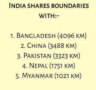
It shares borders with about 7 countries
1) Bangladesh(4096 km sq)
2)China (3488 km sq)
3) Pakistan (3323 km sq)
4) Nepal (1751 km sq)
5) Myanmar (1021 km sq)
6) Bhutan (699 km sq)
7) Afghanistan (106 km sq)
Who wrote the book modern political geography of India?
The longest river here is Ganga 2525 km and Lake is Wular lake (30 to 260 km sq). The highest Peak point k2 (8611 km sq) with Kanchenjunga (8586 km sq) and the lowest point is Kuttanad -2.2m. India has 29 states and 8 union territories.
 |
| Political Geography of India |
Who is regarded as the father of Political Geography?
In which hemisphere India is located?
India is located in the northern hemisphere.
The Evolution of Political Geography of India.
Physiographic divided based on Landforms, Climatic & Natural Vegetation into 5 regions Northern Mountains, Northern Plains, Western Desert, Southern Plateau & Coastal Plains.
The State with Highest Population is Uttar Pradesh and the lowest is Sikkim and in terms of Area, Rajasthan is the highest and Goa marks the bottom row. Gujarat has the highest coastal path with it.
The Lakshadweep and the Andaman and Nicobar Islands are India’s two major island formations and are classified as union territories.
India is having around 14,500 km of inland navigable waterways.
There are twelve rivers that are classified as major rivers, with the total catchment area exceeding 2,528,000 km2 (976,000 sq mi).
All major rivers of India originate from one of three directions and the peninsula region.
Tropic of Cancer the mainline passes through 8 states Gujarat, Rajasthan, Madhya Pradesh, Chhattisgarh, Jharkhand, West Bengal, Tripura, Mizoram.
The std time is 82.3 in Mirzapur(Prayagraj) which passes through 5 states Uttar Pradesh, Madhya Pradesh, Chattisgarh, Odisha, Andra Pradesh.
10 degree Channel separate Andaman & Nicobar. 9 degrees Channel separate Lakshadweep & Minica .8 degree separate Malvdies & Minica.
Books related to the Political geography of India:-
What is the standard meridian of India?
India and Its borders.
Chandigarh with Punjab & Haryana and Hyderabad with Andra Pradesh and Telangana.
At the time of Independence India has 14 states and 6 UT and today 28 states and 8 UT.
This are new states formed in the 21st Century Jharkhand, Uttarakhand, and Chattisgarh in 2000 and Telangana in 2014.
Plzz memorize it or Understand it using the Indian map as it most important in govt exams point of view.
JAY HIND……!!!!


Very informative and good for revision
THANKS alott
Really helpful…..Good notes
Thankss Sir